Файл:Pechora.jpg

Ончылгоч ончымо годым кугыт: 463 × 599 пиксель. Вес сайлык-влак: 185 × 240 пиксель | 371 × 480 пиксель | 593 × 768 пиксель | 791 × 1024 пиксель | 1700 × 2200 пиксель.
Тӱҥалтыш файл (1700 × 2200 пкс, файлын кугытшо: 803 Кб, MIME тӱрлылык: image/jpeg)
Кӱчык возен ончыктымаш
| Возен ончыктымаш |
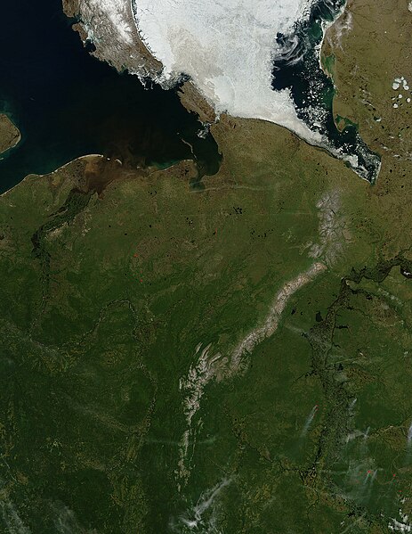
English: Pechora River
sattelite photo On July 3, 2004, sea ice still covered much of the Kara Sea in Northeastern Russia, near the western edge of Siberia, when the Moderate Resolution Imaging Spectroradiometer (MODIS) on NASA’s Aqua satellite captured this image. The southern tip of Novaya Zemlya Island curves out of the upper left corner of the image and is separated from Vaygach Island by Karskiye Vorota Strait. The narrow Yugorskiy Shar Strait, which separates Vaygach Island from mainland Russia, is clogged with sea ice. To the west, image left, the Pechora River is emptying brown, sediment-rich water into the Pechorskoye Sea. The water is probably loaded with mud as the far north thaws for the summer. In the lower right corner of the image, MODIS has detected a handful of fires, marked in red, which are sending light plumes of smoke to the southwest. |
| Важ | Шке пашам |
| Автор | user:Svart |
Лицензирований
| Этот файл находится в общественном достоянии (англ. public domain), так как он был создан NASA (Национальным управлением по аэронавтике и исследованию космического пространства). Политика авторского права NASA гласит, что «Материал NASA не защищается авторским правом, если не указано иное». (См. Template:PD-USGov, страницу политики авторского права NASA или политику использования изображений JPL.) | ||
 |
Предупреждения:
|
Файлын историйже
Файл ончыч могай ыле - ончалнет гын, кече/жапым темдал.
| Кече/жап | Изисӱрет | Кугытшо | Ушнышо | Рашемдымаш | |
|---|---|---|---|---|---|
| кызыт | 21:47, 27 ӱярня 2006 | | 1700 × 2200 (803 Кб) | Svart~commonswiki | '''Pechora River''' sattelite photo On July 3, 2004, sea ice still covered much of the Kara Sea in Northeastern Russia, near the western edge of Siberia, when the Moderate Resolution Imaging Spectroradiometer (MODIS) on NASA’s Aqua satellite captured |
Файлым кучылтмаш
Тиде файлым тыгай велыж кучылтеш:
Файлым чыла вере кучылтмаш
Тиде файл тыгай викилаште кучылталтеш:
- af.wikipedia.org проектыште кучылтмаш
- ar.wikipedia.org проектыште кучылтмаш
- arz.wikipedia.org проектыште кучылтмаш
- ast.wikipedia.org проектыште кучылтмаш
- az.wikipedia.org проектыште кучылтмаш
- be.wikipedia.org проектыште кучылтмаш
- bg.wikipedia.org проектыште кучылтмаш
- bn.wikipedia.org проектыште кучылтмаш
- ca.wikipedia.org проектыште кучылтмаш
- ceb.wikipedia.org проектыште кучылтмаш
- ce.wikipedia.org проектыште кучылтмаш
- de.wikivoyage.org проектыште кучылтмаш
- diq.wikipedia.org проектыште кучылтмаш
- en.wikipedia.org проектыште кучылтмаш
- eo.wikipedia.org проектыште кучылтмаш
- es.wikipedia.org проектыште кучылтмаш
- eu.wikipedia.org проектыште кучылтмаш
- fi.wikipedia.org проектыште кучылтмаш
- fr.wikivoyage.org проектыште кучылтмаш
- ga.wikipedia.org проектыште кучылтмаш
- gl.wikipedia.org проектыште кучылтмаш
- he.wikipedia.org проектыште кучылтмаш
- hy.wikipedia.org проектыште кучылтмаш
- id.wikipedia.org проектыште кучылтмаш
- lmo.wikipedia.org проектыште кучылтмаш
- lv.wikipedia.org проектыште кучылтмаш
- mrj.wikipedia.org проектыште кучылтмаш
- myv.wikipedia.org проектыште кучылтмаш
- mzn.wikipedia.org проектыште кучылтмаш
Тиде файлым чыла вере кучылтмым ончал лекташ.